Photos from the road closure, April 11th

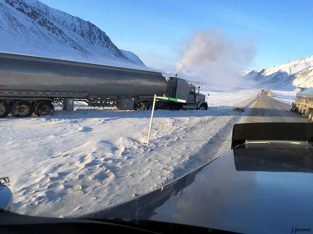
These photos are from when Jack was stuck at the road closure.  He was waiting there 3 days to get unloaded.  As you can see, it was a beautiful couple of days, albeit cold ones.  The rigs in the distance are tractor-like vehicles on tracks with tanks to take the fuel Jack and the other truckers are hauling back to Prudhoe.  The road is now open during the day.  Click on the first and scroll to the right.  More info on the captions.


More photos of the flooding

The last I heard from Jack he was still waiting to be offloaded.  There are a few freight trucks showing up to wait for a chance to get through, but no fuel trucks will be allowed. Those will still be offloaded about 23 miles from Prudhoe.

The below photos are the last of what Jack took before the road closure, on the 1st and 2nd of April.  It’s far from the worst of it.  For the deepest water Jack experienced, click on “On a slow truck to Prudhoe” on the right.

There’s a lot of good information in this article and a couple of photos:  http://www.newsminer.com/news/local_news/alaska-north-slope-truckers-in-limbo-as-dalton-highway-flood/article_311711ce-dff8-11e4-b9be-0bc49e932ff7.html

Update on Jack & the road

Jack was able to call and he is fine.  The road is closed with no sign of being open soon.  He is there with 4 or 5 other trucks waiting to get offloaded to a tractor-type vehicle with tracks.  Jack described it like an International Harvester with triangle tracks.  Several of them are running back and forth to Prudhoe, skirting the flooded area.

I was worried that there were more trucks all having to idle because it’s so cold but that’s not a concern.  There are only a few trucks and some of them have generators so they don’t have to idle for cab heat. And someone brought them food and water some time ago.  He’s not having fun, but he’s not too miserable either.  It’s just a waiting game until he can get offloaded and head back (and then probably head right back up again).

Coldfoot was really busy when Jack went through on Thursday; no one else is being told to head up to Prudhoe except some fuel trucks.  And no one is waiting on the Prudhoe side.  They’ve all been told to go back.  Many have been flown out and since resources are so short they are probably running essential personnel only.

Jack is a bit mad at himself for not leaving town more prepared.  He had 3 gallons of water and some food which is almost gone.  But no extra clothes and all kinds of other stuff it’d be nice to have like a laptop to watch movies on to help pass the time.   He says the people who are handling this mess are working on putting systems in place to make everything more stream-lined, but at present it’s still a work in progress.  This might be the new normal for a while.  Everyone saw the water getting higher and higher and no one could do anything about it, like watching a slow motion disaster.

The below photos are from about 10 days ago when the road was still passable, but barely.  The best way to view them is to click on the first one and scroll through.

Huge snowdrifts near the flooding

This video is from about 10 days ago, it shows what the truckers had to pass through before they got to the flooding, heading into Prudhoe.  And here’s a good article about what’s going on up there.

http://www.ktuu.com/news/news/severed-from-supply-chain-north-slope-is-conserving-resources/32313174


Truck waves on the Dalton

Talk about poor road conditions!  This was about a week ago, before the road closure.  Jack has been told the road will be open tomorrow so he is on his way up.  So sorry to all those who’ve been stuck on the non-home side.

Trucks in this video are going really slow as there’s a layer of glare ice underneath them.  At the end you can see a wave that’s being created by moving trucks.

(Don’t forget you can change the resolution on a YouTube video if it looks blurry, “settings” in the lower right hand corner.)

Sag River overflow & a couple of big bumps

Here’s another video showing water from the Sag River flowing over the Dalton.

And this one shows how the splashing of water has created ice ridges on either side of a flowing area.  Trucks drive over the water and it sprays up and freezes on either side, so now there is a huge dip in the road.  The bottom of the dip is the actual road.  Some people were saying the road has washed out but Jack says no, it’s ice ridges building up and making it looking like a portion of the road has washed out.

(Don’t forget, YouTube automatically picks a low resolution so if you want a clearer picture click on the lower right hand side icon called “settings” and pick a higher number.)

The Dalton has turned into a river!

The Sag River has turned the Dalton into one of it’s branches.  This video was taken on the first day of April.  Road conditions have been getting steadily worse.  The road is currently closed because blowing snow is reducing visibility and they can’t see to clear the road.

More to come.

Before the road got really bad

You may already know that the Sag River has been overflowing the Dalton Highway about 20 miles from Prudhoe Bay.  The below video shows what the road looked like about 2 weeks ago.  Jack was riding into Prudhoe with someone else because his truck broke down.  The river runs along the Dalton for a very long ways on the east side of the road.

A lot more to come!


Sag River flows over the Dalton

The Sag River has been overflowing its banks this past month.  So much so that it has been giving the truckers and the State (of Alaska) a bit of a headache.  The photos below are from about 10 days ago and a lot more drama has happened since.  We’ll have updated photos for you in a couple of days.

The Sag River follows the Dalton Highway for quite a few miles during the last 100 miles of the road, when you’re nearing Prudhoe.  So when we say it

The Sag River and the Dalton Highway.

The Sag River runs along the Dalton Highway for about 100 miles.

is overflowing near the road it could be happening at many different spots, and it is doing just that.   According to Jack, overflows are normal but this river overflowing in this area is an unprecedented occurrence since he has not known for it to have ever happened before.  No one he’s talked to has either.  It’s not an uncommon thing for rivers to do though.

All the talk now is if the State will be able to handle the situation when actual break up occurs.  Temperatures are still well below zero pretty much all the time right now so we haven’t seen the worst of it.  The question is, what’s going to happen during break up when everything starts to really melt?

Click on the first photo and scroll through to see them full size with explanations.