Truck drivers stop at this roadside spring to clean their lights. Most of them use a bucket with a brush but Jack recently got a battery powered pressure washer (not pictured here because we’re camping, not trucking). Some of them use it for drinking water also even though there’s a sign that says it hasn’t been deemed potable. It tastes great! We stopped here in 2020 on our way up north to go “camping with guns” as Jack calls it when he doesn’t get a moose. 🙂
Jack welcomes you to the Dalton, but kind of in the wrong order. Instead of just getting on the Dalton, he’s just leaving it. At the very end you can see the Elliot Highway to the right where it continues on to Manley, and at that point he has left the Dalton and is on the Elliot. It’s a lot simpler than it sounds. The Elliot Highway was finished in 1959, goes north from Fairbanks and turns west toward Manley, a town a few miles from the Tanana River. The Dalton Highway was built in the 1970s to supply and access the Trans-Alaska Pipeline and starts where the Elliot turns west to Manley. If Jack could, he’d redo this video so it goes the right away, welcoming you to the Dalton at it’s beginning. But it’s such a beautiful day!
Well, he didn’t really swim, because the sea is very shallow. But he submerged everything but his head!
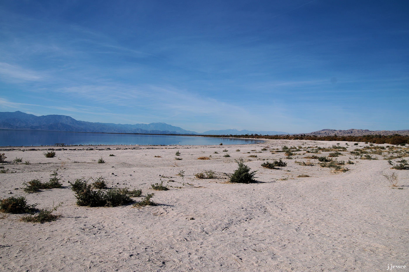
If you don’t know anything about the Salton Sea you may be wondering why this is even a topic. But if you have heard of the sea’s notoriety, you might be alarmed. The sea is located in California, near Palm Springs, and it was actually created when irrigation canals from the Colorado River overflowed in 1905. The Salton Basin is over 200 feet below sea level so the water flowed to the lowest point and stayed there. Native Americans say this area has flooded in cycles over the centuries. Now though, it is saltier than the Pacific Ocean and the sad benefactor of much agricultural runoff.
We don’t know if it is dangerous to swim in… search the internet and you will find arguments going both ways. Why Jack insisted on swimming in it I do not know. Maybe it’s a been-there-done-that type of thing. We do know that it was a fun day of exploration full of so many normal and decrepit things to photograph like the multitude of flies that love dark-colored cars, and the infinitesimally interesting makeup of the ground.
Dead fish abound and the beach in some parts is actually made up of massive amounts of bones and shells of dead sea creatures. What look like millions of small barnacle carapaces are what you actually walk on to get to the shore. And part of the shore itself is like a crust that you can put your foot through. Not exactly a body of water that screams “Jump in!”
That being said, there are tons of seagulls, sandpipers and other water birds foraging on the shore and generally making themselves at home. They eat a tiny worm which is prolific, according to one article I read to Jack in the car on the way there, but the only fish that can survive the high salinity is tilapia.
There is a certain tragic beauty in places like this. The area was a popular vacation destination in the 1950s and 60s but things took a downturn in the 70s and lakefront property turned into dry foul-smelling plots worth a fraction of what they were purchased for. The shrinking of the sea caused increasing salinity levels which in turn caused massive fish die-offs. Hence the beach (or shall we call it a fishboneyard) became a testament to a bounty of riches that was no longer.
But we had a fabulous time and even got to meet some new people!
There’s a video at the end that shows us at the beach along with piles of dying flies and an audio of bubbles of hot steam from the San Andreas fault hitting the surface in the far distance. For a great but alarming short article on the Salton Sea, go to The dying Salton Sea on USA Today.
Jack with our new friends Llyod Duro & Vilma, of the Torres Martinez Desert Cahuilla Indians. Lloyd is with the TM Birdsingers…check them out on YouTube.
If any of you are very familiar with the great state of Colorado you may have heard of the Shelf Road that runs between the towns of Canon City and Cripple Creek (lots of Cs in that part of the world). It’s a mountainous dirt road with steep drop offs, hair-raising corners, and not even a hint of a guard rail on the whole 24 miles.
The Shelf Road is actually part of the Gold Belt Byway, a string of scenic roads in Colorado so called because of the gold mining in the area.
The average person wouldn’t drive this road, but my husband is not your average person. After buying a pick up in Texas and a camper to sit on top of it in Colorado, he chooses to christen our new rig by taking it on the Shelf Road. Let me just say right now, as the person who sat on the side of the ledge, that it was total insanity. It may have been enjoyable in a Jeep or something but as it was, our huge lumbering beast met a small truck and I was so busy white-knuckling it that I forgot to take a photo!
Below are photos of the drive, with some captions that you can see if you click on the image and scroll to the right, and below those are some photos of Cripple Creek and the mountaintop mine nearby.
Beautiful unassuming red dirt road…
…until you look down!
Truly on the side of a mountain.
A cross and some lovely metal art to memorialize someone.
One lane, around a corner !?!
It’s a really long way down.
24 miles of this!?!?
That’s an old collapsed barn down there.
Strange to find a big warehouse out in the middle of nowhere but there are mine accesses, tours, and roads to 2 ghost towns also.
Having a great time I’m sure, while his wife has a heart attack.
A great blue heron flying overhead.
Looking back the way we came.
That’s quite a road but I don’t really understand why it’s here, considering how much it probably costs to maintain.
Not taking his eyes off the road.
It had snowed recently, hence the puddles.
Another turn !?!
Beautiful valley VERY far down there.
How long does this go on??
Yay, falling rocks too!
Finally heading down the mountain.
The rig’s doing a pretty good job.
Some interesting drainage ditches.
A great blue heron flapping it’s wings in the breeze, practicing?
Still a lot of one lane portions, but it’s easier to breathe.
Notable rock formation.
I suppose Jack would just love to explore that old mine, thank goodness it’s locked.
What is a house doing out here and how did it get here??
A wild turkey gets startled by our lumbering beast.
Our reward for completing the harrowing Shelf Road was getting to Cripple Creek, a town that is clearly proud of their mountaintop removal! Here is a satellite image of the mine and some from the town itself. Hope you get there someday if you haven’t been already.
The view driving toward Cripple Creek
A satellite image of Cripple Creek & Victor Gold Mine.
A nice dusting of snow livens up the scene.
It’s amazing how big that mine must be.
This old structure is called the “Morning Glory Ore House” and was moved here in 2012 for preservation.
Another dark hole in the side of a mountain.
Now THAT is a retaining wall!
Don’t know the story behind this monster but there’s got to be one.
Tailing piles, I suppose.
Not sure if I’m going to be on board for this again. Luckily we’re leaving in a different directon.
Lots of historical buildings around here.
They sure love their donkeys, maybe too much. A bartender told us a story about the townspeople going after the donkeys that left town and bringing them back whether they liked it or not.
During the day…
and on a chilly night with some snow.
We left about $200 up, not too bad!
More mining stuff on the way out of town.
Would love to come back some day when we have more time.
Happy Fourth of July! Here are some photos from Bandelier National Monument in New Mexico. Cliff dwellings are always fun to see and this is one of the best places to experience them. There’s more info on the captions and in order to see them and the photos at original size, click on the first photo and scroll to the right. Be careful with those fireworks!
Looking down into the canyon where the Native American cliff dwellings are.
Diorama of some of the dwellings that were not attached to the cliff.
“Bandelier National Monument protects over 33,000 acres of rugged but beautiful canyon and mesa country as well as evidence of a human presence here going back over 11,000 years. Petroglyphs, dwellings carved into the soft rock cliffs, and standing masonry walls pay tribute to the early days of a culture that still survives in the surrounding communities.” (nps.gov)
This diorama shows how the dwellings were attached to the cliff and connected to the alcoves.
“The Ancestral Pueblo people lived here from approximately 1150 CE to 1550 CE. They built homes carved from the volcanic tuff and planted crops in mesatop fields.” (nps.gov)
The actual cliff wall.
If you look closely there appears to be some holes in the cliff wall.
The first ruins you come to, a circular building that was a religious gathering place.
The circular diorama in the visitor center was of these ruins which were made up of many individular dwellings, some of which were at least 2 stories high.
The holes next to the square entrances were for posts that supported man-built dwellings that stuck out from the side of the cliff.
Jack, showing the size of the entrance.
Inside the alcove.
Looking back toward the visitor center.
“By 1550, the Ancestral Pueblo people had moved from this area to pueblos along the Rio Grande. After over 400 years the land here could no longer support the people and a severe drought added to what were already becoming difficult times.” (nps.gov)
Judy, climbing a ladder to check out an alcove.
These steps were put in by the park service, as were the ladders.
Looking down on the circular ruins, some of which were at least 2 stories high.
Inside an alcove where the soot built up from years of fires.
Imagine dwellings made of rock standing high enough to cover those cave entrances.
“Corn, beans, and squash were central to their diet, supplemented by native plants and meat from deer, rabbit, and squirrel. Domesticated turkeys were used for both their feathers and meat while dogs assisted in hunting and provided companionship. ” (nps.gov)
Post holes for supporting the rock buildings that leaned against the cliff wall. (The engraving may be vandalism.)
The artwork to the right has been covered with plexiglass for safe-keeping.
What a great day.
Leaving the visitor center and other buildings of Bandelier National Monument. Thanks for looking!
Jack bought a new pick up truck! We picked it up in Amarillo, Texas and drove through Palo Duro Canyon State Park before heading on to New Mexico. Click on the first one and scroll to the right if you are interested!
Jack and his new truck!
Look at those huge ears on that jackrabbit!
An adorable prairie dog family (and could that be a burrowing owl in the background?).
Very different soils from what we are used to in Alaska.
Windmills and jack pumps everywhere!
Amazing dips and depressions in these brick roads, not all that different from what we deal with!
On The High Road to Taos (highway 518 in New Mexico) Jack and I ran into a pretty powerful hail storm. Even Jack felt the need to pull over at this point. At the very beginning of the below video you can see a little bit of lightning and later the road was totally white, it looked like snow. There are photos below it.
Hail on Jack’s truck after the storm mostly passed.
It looks like snow!
But it is clearly small balls of ice.
Deciding to head out.
Not sure if it melted right away seeing as it was pretty cool up in the mountains.
It was still on the truck when we stopped at a gas station about an hour later!
The day before we were enjoying the beautiful (but cool) weather of Taos.
Here are more photos of our late summer camping trip up the Steese Highway. Chilly, but hardly a cloud in the sky…
You’ll see Davidson Ditch, a water pipe built in 1920s, that runs 90 miles along the Steese Highway. It used to bring about 180,000 gallons of water per day to the gold dredges in Fox, Alaska from the Chatanika River.
(Click on the first one and scroll to the right.)
Sitting around our campfire, the northern lights decided to give us a show.
Jack, lovin’ life.
An ember from the fire timed itself perfect for our long shutter speed.
The Steese Highway, one of the less populated camping destinations.
There are several nice roadside memorials on Alaskan highways, but we both agree this is the best one we’ve seen.
It’s only late August, but that means fall up here, about 60 miles north of Fairbanks.
Even farther north at Twelvemile Summit Wayside (about 80 mile Steese).
Probably the best time to drive the Steese Highway, late summer.
State camp, Montana Creek Station (road maintenance station).
Lots of mining on the Steese Highway.
And lots of burnt forest.
Davidson Ditch snakes its way to Fox, Alaska (about 8 miles north of Fairbanks).
Davidson Ditch is practically in this house’s back yard.
Chatanika Lodge, a most important place to visit if you come to Alaska. Tons of interesting stuff in there. About 40 mile Steese Highway.
This is directly across from Chatanika Lodge, a very old mining site with a gold dredge (on the right) that used to float.