Avalanche blocks the road on Atigun Pass

A few days ago Jack was held up for a couple of hours because of this avalanche that blocked the road on Atigun Pass.  To me, it looks like a small avalanche.  But Jack says this is the average amount of snow that usually falls on the road in this spot.  Other areas involve more snow, or less.

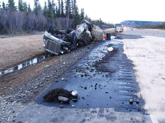
If a truck was caught in the path of this avalanche, it could have pushed the truck over the guard rail and ended up rolling it down the hill.  This is very rare nowadays since the State of Alaska does more avalanche control, shooting artillery at the mountain to dislodge the snow.

You can see the blocked road, the loader removing the snow, and also the melt water that was running alongside the road before the avalanche and which is crossing the road afterward.  The last photo shows the loader dumping water as well as snow.  They are best viewed if you click on the first one and scroll to the right.  I had to substantially lighten the photos because of low light conditions.  You can see the sun over the next hill and all the trucks waiting on the other side of the blockage.  This is about 10:30 at night.

Dalton Highway, April 16th & 17th

These photos are the last of the ones Jack took from when the road was in bad condition.  It’s much improved now, to the point where Jack says there’s nothing to take photos of.  When the melt starts up there though, who knows what will happen.

Accident on the Parks Hwy, diesel spilled

This truck wrecked on the Parks Highway yesterday.  The driver is fine but he was cited for negligent driving.  The accident spilled about 2000 gallons of diesel into a ditch.  Below is a link to a short article in the Fairbanks Daily News-Miner about it.

http://www.newsminer.com/news/local_news/fuel-tanker-spills-gallons-in-parks-highway-crash/article_b4c220f2-e851-11e4-9c95-cfcef7850e83.html


Accident on the Parks Highway

Photo by Alaska Department of Transportation and Public Facilities via Newsminer.com


Heavy Equipment (one that floats!)

Here are the rest of the photos from when Jack drove through the flooded area, the portion of the road that was recently closed because of the overflow of the Sag River onto the Dalton.  There is a HUGE tracked vehicle that Jack says can float!  I can’t see how that’s possible but supposedly, if it breaks through the ice, it won’t sink to the bottom of whatever it is on.  In his case it’s a matter of a few feet to the ground.  But it’s just hard to imagine either way.

Click on the first one and scroll to the right.

Dalton road conditions, April 15th

The road is in much better condition now, but it’s still a work in progress.  It’s open 24 hours now but only one lane with a pilot vehicle.  More info on the captions of the photos.  They were taken the 15th of April.  The very first photo is out of order – I put it in front to show what the road is supposed to look like at this time of year.  It was taken closer to Prudhoe, after Jack passed through the hazardous area.

Click on the first one and scroll to the right.

Photos from the road closure, April 11th

These photos are from when Jack was stuck at the road closure.  He was waiting there 3 days to get unloaded.  As you can see, it was a beautiful couple of days, albeit cold ones.  The rigs in the distance are tractor-like vehicles on tracks with tanks to take the fuel Jack and the other truckers are hauling back to Prudhoe.  The road is now open during the day.  Click on the first and scroll to the right.  More info on the captions.


More photos of the flooding

The last I heard from Jack he was still waiting to be offloaded.  There are a few freight trucks showing up to wait for a chance to get through, but no fuel trucks will be allowed. Those will still be offloaded about 23 miles from Prudhoe.

The below photos are the last of what Jack took before the road closure, on the 1st and 2nd of April.  It’s far from the worst of it.  For the deepest water Jack experienced, click on “On a slow truck to Prudhoe” on the right.

There’s a lot of good information in this article and a couple of photos:  http://www.newsminer.com/news/local_news/alaska-north-slope-truckers-in-limbo-as-dalton-highway-flood/article_311711ce-dff8-11e4-b9be-0bc49e932ff7.html

Update on Jack & the road

Jack was able to call and he is fine.  The road is closed with no sign of being open soon.  He is there with 4 or 5 other trucks waiting to get offloaded to a tractor-type vehicle with tracks.  Jack described it like an International Harvester with triangle tracks.  Several of them are running back and forth to Prudhoe, skirting the flooded area.

I was worried that there were more trucks all having to idle because it’s so cold but that’s not a concern.  There are only a few trucks and some of them have generators so they don’t have to idle for cab heat. And someone brought them food and water some time ago.  He’s not having fun, but he’s not too miserable either.  It’s just a waiting game until he can get offloaded and head back (and then probably head right back up again).

Coldfoot was really busy when Jack went through on Thursday; no one else is being told to head up to Prudhoe except some fuel trucks.  And no one is waiting on the Prudhoe side.  They’ve all been told to go back.  Many have been flown out and since resources are so short they are probably running essential personnel only.

Jack is a bit mad at himself for not leaving town more prepared.  He had 3 gallons of water and some food which is almost gone.  But no extra clothes and all kinds of other stuff it’d be nice to have like a laptop to watch movies on to help pass the time.   He says the people who are handling this mess are working on putting systems in place to make everything more stream-lined, but at present it’s still a work in progress.  This might be the new normal for a while.  Everyone saw the water getting higher and higher and no one could do anything about it, like watching a slow motion disaster.

The below photos are from about 10 days ago when the road was still passable, but barely.  The best way to view them is to click on the first one and scroll through.

Huge snowdrifts near the flooding

This video is from about 10 days ago, it shows what the truckers had to pass through before they got to the flooding, heading into Prudhoe.  And here’s a good article about what’s going on up there.

http://www.ktuu.com/news/news/severed-from-supply-chain-north-slope-is-conserving-resources/32313174


On a slow truck to Prudhoe (deep water!)

Check out how deep the water is that’s coming from the Sag River and flooding the Dalton.  Each truck is basically a slow moving island unto itself and if one were to break down, well, just don’t think about that.  This was taken before the days-long closure of the road, a little over a week ago.  The governor has declared a state disaster.